
Rippingale - A History
Rippingale Parish, situated in South Lincolnshire, has a population of approximately 950, living in some 350 homes. The Parish straddles the A15, five miles north of Bourne and stretches eastwards to the South Forty Foot Drain. The Village of Rippingale lies between the A15 and the B1177.
Rippingale Parish is within the administrative area of South Kesteven District Council (SKDC) which, amongst other roles, serves as the local planning authority. Services such as education and transport are provided by Lincolnshire County Council, which also supports joint strategic planning with the District Council, as well as minerals and waste planning matters.
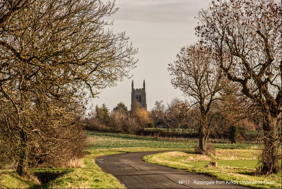
Rippingale is a small, peaceful village nestling in a shallow valley, with open farmland on all sides. It sits on the edge of the Fens and is approached along tree-lined roads, through agricultural land, mostly free of development. Car Dyke, a former semi navigable ancient waterway from Peterborough to Lincoln, runs across Rippingale Fen; it was built by the Romans in approximately 125AD as they developed the Fens. It linked the River Nene and the River Witham but was probably only passable in sections, though it was large enough for boats transporting grain and such like. Rippingale is located close to and east of the Roman road to Lincoln, which was a branch of Ermine Street. A part of it forms the section of the A15 than runs through Rippingale Parish. The village was sited, in Roman times, along a line of wells close to the old Roman road.
The Parish of Rippingale in the Diocese of Lincoln is first mentioned in 806AD as “Riapencal”, being three syllables of Celtic origin meaning “upper, river, forest”. The village road layout is Celtic in origin. The village is also mentioned in the Domesday Book of 1086 as Repinhale. Hereward the Wake is said to have rented land in Rippingale. The centre of the village has many medieval structures: the Church, St Andrew’s, can be traced to at least the 13th Century and there are 13th Century effigies of a knight and a lady within the body of the Church. Opposite is a public house, the Bull and there are surviving parts of a manor house next to the Church. There are also the remains of a medieval standing stone cross on the Village Green. A number of Grade II listed farmhouses exist within the village.
A single-line railway was opened in 1871, which transported crops to various parts of the county and brought household goods and coal to the village. The station closed in 1965 and was subsequently converted into a private residence. The previous and present owners have maintained the character of the station and goods yard, including a stretch of line, the crossing gate and an engine. This is a popular historic feature at the start of Rippingale Fen.
Census records show that the population was 488 in 1801. There were slight increases over the next 100 years, but in 1911 the population was 469. Since then, the population has grown steadily, to 837 in 2001 and to 929 recorded in 2011. The area, throughout chronicled history, has been devoted to farming. The Fens were, until the 1600s, undrained marshland on which life was extremely hard. However, they provided great quantities of wildlife, fish, fuel, osier, reed and sedge to the local population. During the early years of the 17th Century areas of the Fens were drained to provide enclosed land for crops of coleseed rape and corn, but this was unpopular as it denuded the inhabitants of their livelihood. As a consequence of the 1640s Civil War, the Fen landers were able to destroy these works, and the Fens reverted to their former condition. Although drainage was imposed in the late 18th Century, it was not until the 19th Century, with the advent of steam power for pumping, that the Fens were efficiently drained to provide the fertile agricultural areas seen today.
The higher ground to the West of Rippingale Parish was, from early times, largely devoted to stock rearing. However, in the 17th Century barley, peas and wheat were grown on arable land, increasing greatly since the 19th Century, with the draining of the Fen. Livestock remained on farms until the Second World War and mixed farming was practised. The use of horses on the land was widespread, giving rise to supporting businesses, such as a blacksmith and a saddlery. There were several shops in the village and a garage; at one time eight alehouses were readily supported by an influx of temporary workers at harvest time. Since the Second World War the area has been almost wholly devoted to the production of a variety of arable crops, including sugar beet. Flower growing was practised, but this has ceased. Currently, more land has been devoted to other crops such as rapeseed, and farming has become heavily mechanised resulting in loss of employment locally.
The village still houses four farms and can be approached from four directions, from the west by two roads leading from the main A15 Bourne to Sleaford Road, and from the east and south each by roads leading from the B1177. All these approaches lead to the centre of the village. The roads are all bounded by ash or lime trees with some oaks and chestnuts and are free of development until well into the boundaries of the village. The centre of the village has an interesting road layout, which has been established over several hundred years: the older roads are bounded by a footpath on one side and a drainage ditch on the other. There is no school, which closed a number of years ago, pupils commute to Bourne, Morton or Pointon. The last shop also closed. Technological developments such as high-speed broadband have created an increase in small businesses working from home. There are now over 30 such businesses in the village. Farming is still the only major industry, being concentrated into several large businesses using modern machinery and techniques. There has been little change in the Fen area, which is devoted wholly to farming. Most people commute to work outside the Parish.
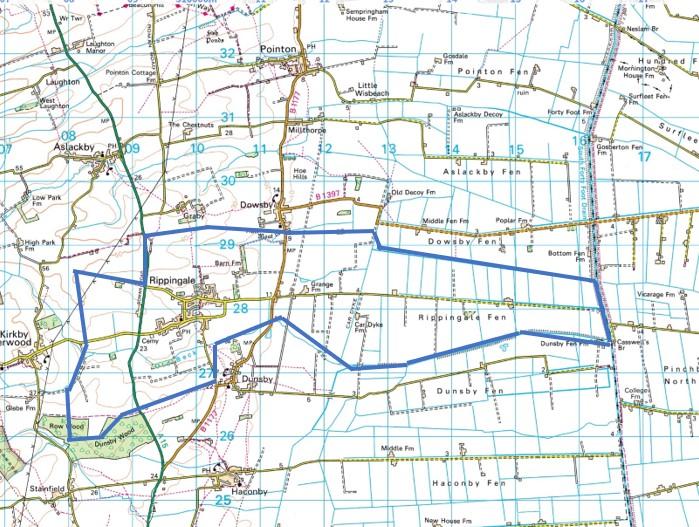
Rippingale Parish boundary map